The Day America Took My Breath Away
I’ve driven thousands of miles across this country, from California’s coastal cliffs to Maine’s rocky shores, but nothing prepared me for the Beartooth Highway. This 68-mile stretch of U.S. Route 212 between Red Lodge, Montana, and Cooke City, Wyoming, isn’t just a road—it’s a transformation. In less than two hours, you climb from lush valley floors to alpine tundra at 10,947 feet, watching the world change through your windshield like a living postcard.
I tackled this drive on a crisp June morning, windows down despite the thin mountain air, mouth literally agape as each switchback revealed another vista more ridiculous than the last. Here’s everything you need to know to experience America’s most beautiful roadway for yourself.
Why This Road Hits Different
The Beartooth Highway earned its reputation as “America’s most beautiful roadway” for good reason. Charles Kuralt called it “the most beautiful drive in America,” and after experiencing it firsthand, I’m not arguing. What makes it special isn’t just one view—it’s the relentless procession of world-class scenery that refuses to let you catch your breath. After tackling other scenic routes across America, I can confidently say this one stands apart.
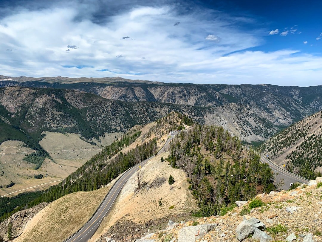
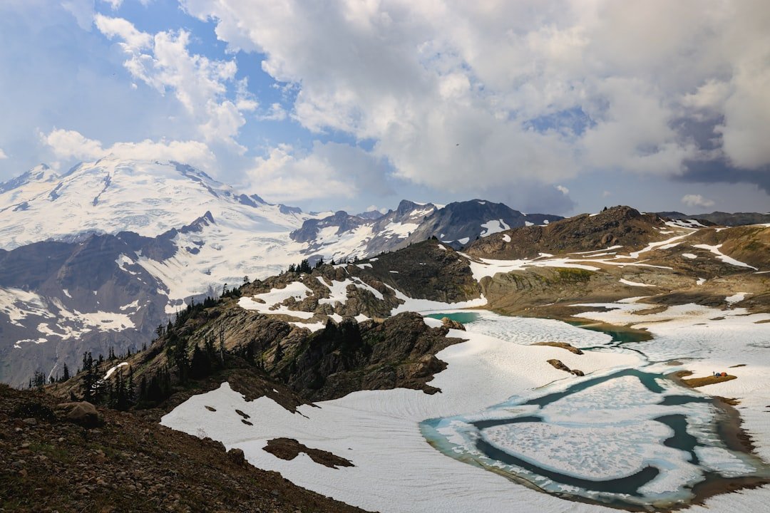
You’re not just looking at mountains; you’re driving through them. The highway cuts through the Absaroka and Beartooth ranges, crossing the Beartooth Plateau—one of the largest contiguous areas of tundra in the Lower 48. At its highest point (Beartooth Pass), you’re standing on the roof of the Northern Rockies, surrounded by peaks that scrape the sky while glacial lakes sparkle like scattered diamonds below.
What surprised me most was the variety. One minute you’re winding through dense forests with the scent of pine filling your lungs, the next you’re exposed to endless alpine meadows dotted with snow patches that survived the winter. The road itself is an engineering marvel, clinging to mountainsides with drop-offs that’ll make your passengers grip the door handle (pro tip: let them drive if they’re nervous).
When to Go: Timing Is Everything
The Beartooth Highway has a short season—typically open from late May through early October, weather permitting. I timed my June visit for peak wildflower season, and the hillsides were exploding with color. If you’re chasing blooms like I was, aim for mid-July through early August when the alpine meadows transform into carpets of purple, yellow, and white flowers that contrast spectacularly against gray granite peaks.
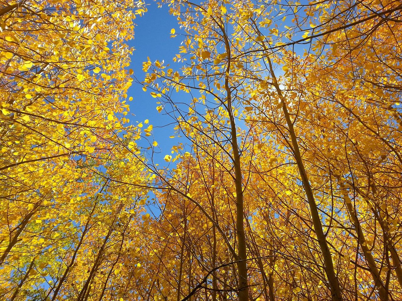
Fall brings its own magic. Late September through early October offers crisp temperatures, thinner crowds, and aspen groves turning brilliant gold against evergreen backgrounds. Winter? The road closes completely due to snow accumulation that can reach 30 feet deep. Spring opening dates vary wildly—I’ve seen it open as early as May 20th and as late as mid-June, so check current conditions before you go.
Whenever you visit, start early. I began my drive at 7 AM from Red Lodge, and the early morning light painting the peaks was worth the lost sleep. Plus, you’ll beat the RV traffic that can make the narrow switchbacks stressful later in the day.
Starting Point: Red Lodge, Montana
Your adventure begins in Red Lodge, a charming mountain town that feels like the Rockies’ best-kept secret. I rolled in the night before and grabbed dinner at a local spot, chatting with locals who warned me about the elevation gain (good advice—Red Lodge sits at 5,555 feet, and you’ll climb another 5,400 feet from there).
Spend your pre-drive morning exploring Red Lodge’s main street, picking up road trip snacks and filling your tank—there are zero services once you leave town. The local fly shops are legendary if you’re into fishing (the nearby Stillwater River is primo trout territory), and the Red Lodge Mountain area offers hiking trails if you need to shake out your legs before the drive.
Pro tip: Check your tire pressure and brakes before leaving. The descent from Cooke City back toward Red Lodge involves steep grades that’ll test your vehicle’s stopping power, especially if you’re towing anything or driving a heavily-loaded rig.
The Climb: From Valley Floor to Alpine Tundra
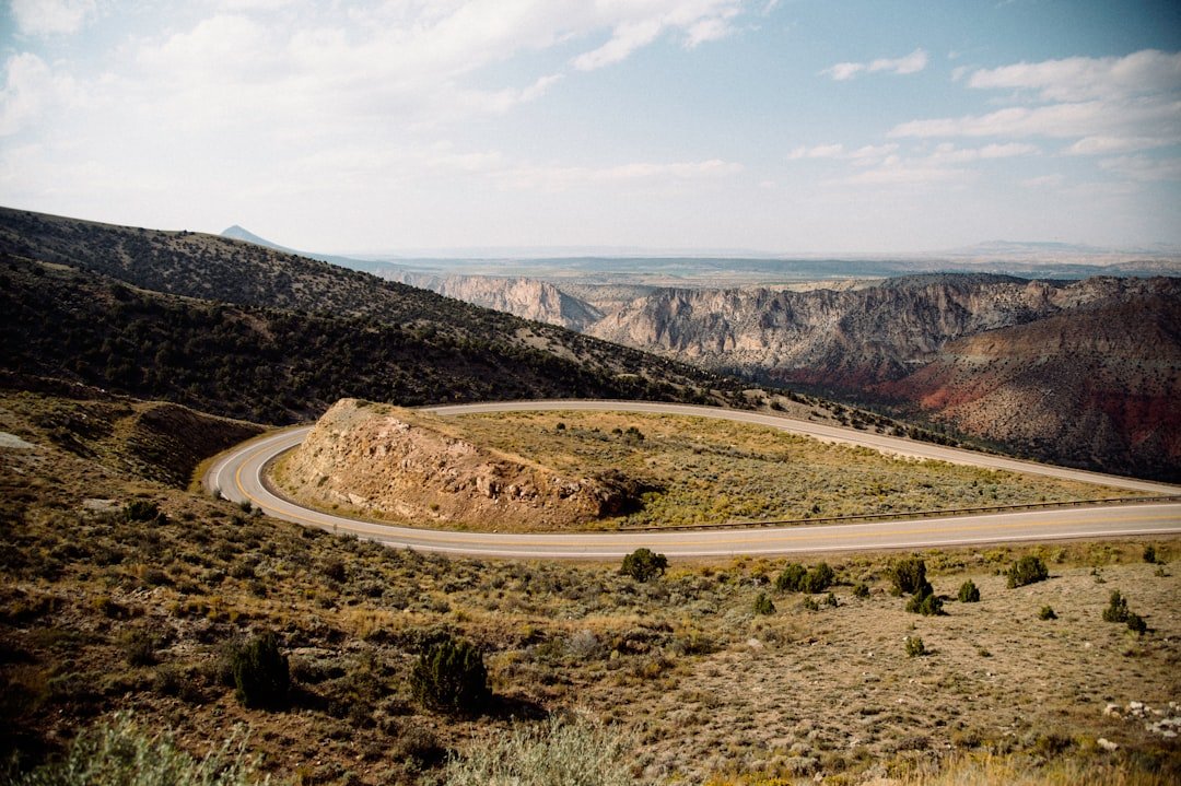
Leaving Red Lodge, the road immediately starts climbing. You’ll wind through the Rock Creek Valley, following a crystal-clear stream that’s popular with fly fishermen. The first 15 miles are relatively gentle—a warmup for what’s coming. I found myself stopping frequently at pullouts, each turnout offering better views than the last.
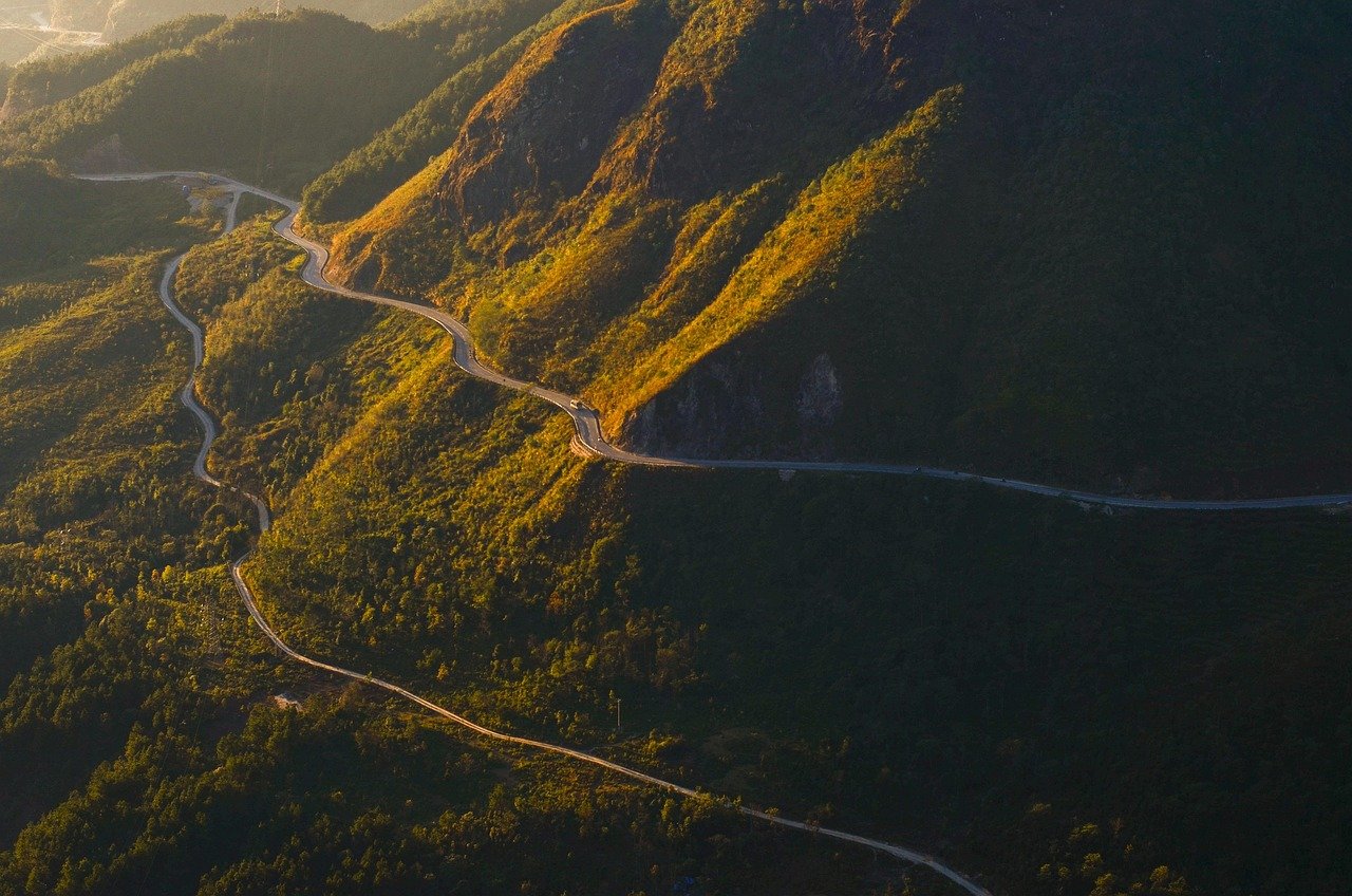
The real drama begins around Mile 15, when the road starts switchbacking up the mountainside in earnest. This is where your passengers will start earning their keep as spotters—many pullouts require backing out to continue, and tight turns demand full attention. I was glad I’d packed a reliable phone mount for navigation and hands-free photos.
As you climb, watch the vegetation change. Dense pine forests give way to subalpine fir, then to stunted krummholz trees bent by persistent winds, until finally you break out above treeline into a world of granite and tundra. The transformation happens so gradually you barely notice, until suddenly you’re surrounded by an alien landscape of rock and snow and endless sky.
Beartooth Pass: The Roof of the Rockies
At 10,947 feet, Beartooth Pass isn’t just the high point of the drive—it’s one of the highest elevation highways in America. The air here contains about 30% less oxygen than at sea level, which explains why walking from your car to the overlook might leave you unexpectedly winded. I learned this the hard way while trying to run up a small ridge for a better photo angle (spoiler: I didn’t run far).
The pass area offers several legitimate hiking trails if you’re acclimated and prepared. I hiked a short distance from the parking area, following a ridge that offered 360-degree views of endless peaks stretching to the horizon in every direction. At these elevations, weather changes fast—blue skies can turn ominous in minutes, so I kept my lightweight rain jacket accessible despite the morning sunshine.
This is also prime wildlife territory. I spotted mountain goats clinging to impossible cliffs above the road, their white coats blending perfectly with the snow patches. Marmots whistle warnings from rocky outcrops, and if you’re lucky (as I wasn’t), you might see bears or wolves—though sightings from the road are rare. Keep your distance from any wildlife and never feed them, no matter how habituated to humans they seem.
Must-Stop Pullouts and Overlooks
The temptation to stop at every turnout will be strong, and honestly? Give in to it. Some highlights I won’t soon forget:
Rock Creek Vista Overlook: About 12 miles from Red Lodge, this viewpoint offers your first big look at the valley you’re leaving behind. The parking area is large and makes for a perfect leg-stretch before the serious climbing begins.
Beartooth Falls: A short hike from a pullout around Mile 20 leads to this waterfall cascading through granite cliffs. The trail can be slippery, so wear proper footwear—I saw someone attempt it in flip-flops and immediately regret that life choice.
Pilot and Index Peaks: These twin sentinels dominate the skyline for miles and are some of the most photographed mountains in the region. There’s a particularly good pullout around Mile 25 where the peaks frame perfectly against the sky.
Island Lake: One of many alpine lakes along the route, but Island Lake stands out for its crystal-clear waters reflecting surrounding peaks. There’s a trail around the lake if you have time for a hike—I wished I’d budgeted an extra day to explore this area more thoroughly.
Top of the World Store: At 9,080 feet, this is your last chance for supplies and a bathroom break before the final push to the pass. The prices reflect their remote location, so stock up on water and snacks in Red Lodge instead.
The Descent into Wyoming
After the pass, the road gradually descends toward Cooke City, Montana, passing through landscapes that feel more like another planet than another state. The Wyoming section feels wilder and more remote, with fewer services and even more dramatic scenery. This is grizzly country, so I kept my bear spray accessible during stops, even for short nature breaks.
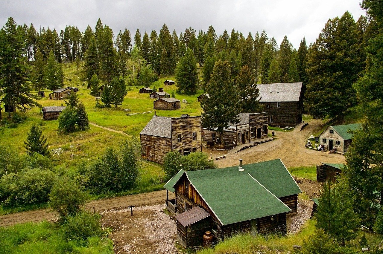
Cooke City itself is a historic mining town that feels frozen in time. Year-round population hovers around 100 people, but summer brings travelers passing through on their way to Yellowstone’s Northeast Entrance (just 4 miles away). I grabbed lunch at a local café and chatted with the bartender about living in such an isolated place—she told me about winter storms that bury the town for weeks at a time, making me appreciate the summer driving conditions even more.
Connecting to Yellowstone National Park
One of the Beartooth Highway’s biggest draws is its position as a gateway to Yellowstone. From Cooke City, it’s a short drive through the park’s Northeast Entrance to the Lamar Valley—often called “America’s Serengeti” for its incredible wildlife density. I spent the afternoon there watching bison herds with calves in tow, and even spotted a wolf pack lounging near a river (bring compact binoculars if you want serious wildlife viewing).
Many people combine the Beartooth drive with a Yellowstone trip, and it’s a natural pairing. You can easily make a multi-day loop: Beartooth Highway one direction, through Yellowstone, then return via the Chief Joseph Scenic Byway (Highway 296) for different views of the same stunning country. If you’re planning a broader national parks tour, check out the best national parks to visit in spring.
Vehicle Preparation and Safety Tips
This drive demands respect from both driver and vehicle. Here’s what I learned the hard way so you don’t have to:
Vehicle choice matters: While any car can technically make the drive, you’ll be more comfortable in something with decent power for climbing and good brakes for descending. I saw everything from motorcycles to massive RVs making the trip, but the RV drivers looked significantly more stressed at the switchbacks.
Check your brakes: The descent from Cooke City back to Red Lodge involves sustained downhill grades. Engine braking is your friend—shift into a lower gear and let your engine do most of the work rather than riding your brakes the whole way.
Fuel up in Red Lodge: There are no services between Red Lodge and Cooke City (except the expensive Top of the World Store). Fill your tank in Red Lodge and carry extra water, especially if you’re traveling with pets or planning to hike.
Weather awareness: I encountered sunshine, clouds, and brief rain all within the same hour. Summer storms can bring sudden hail and lightning at these elevations, so monitor the sky and be prepared to wait out weather in your vehicle if necessary.
Cell service: Don’t count on it. Service is spotty at best and nonexistent in many sections. Download offline maps and let someone know your planned route before you leave—there’s minimal traffic on some sections, so help could be a long time coming if you break down. For serious road trips like this, consider equipping your vehicle with a dash cam for complete visibility and peace of mind.
Altitude sickness: If you’re coming from sea level, the rapid elevation gain can knock you sideways. Stay hydrated, avoid alcohol the night before, and don’t push yourself physically until you’ve acclimated. I felt fine driving but got winded easily during short hikes—totally normal at 11,000 feet.
Packing Essentials for the Drive
Beyond standard road trip gear, here’s what made my Beartooth Highway experience better:
Layers: Temperature at the pass can be 30+ degrees colder than in Red Lodge. I wore shorts in town but needed a fleece and windbreaker at the pass. Pack versatile layers so you’re comfortable regardless of conditions.
Sunscreen and sunglasses: The UV index at 11,000 feet is no joke. Even on cloudy days, you’ll burn faster than expected. I learned this the hard way and spent the next few days with a embarrassingly red face despite only being outside for short periods.
Camera gear: You’ll want to document every mile, but consider the weight. I brought my DSLR and found myself leaving it in the car for short stops because it was too much to carry. My phone captured 90% of my photos and was always accessible.
Footwear: If you plan to explore beyond the pullouts, bring proper hiking boots with good traction. The trails can be rocky and slippery, especially near waterfalls or in areas with lingering snow patches.
Camping and Overnight Options
If you’re not rushing through (and you shouldn’t be), there are several ways to extend your Beartooth experience:
Dispersed camping: National Forest land along the route allows primitive camping for free. I spotted several established sites along gravel side roads, though they fill early on summer weekends. Bring everything you need and practice Leave No Trace principles—this is pristine wilderness that deserves respect.
Developed campgrounds: Several campgrounds along the route offer basic amenities for a fee. Most operate on a first-come, first-served basis, so arrive early (before noon) on weekends to secure a spot.
Red Lodge lodging: If you prefer a bed and shower, Red Lodge offers everything from historic hotels to motels. Book ahead—this small town fills up fast during peak summer season, especially on weekends.
Yellowstone camping: If you’re continuing into the park, reserve campground sites well in advance (some book up six months out for summer dates). Inside the park, you’ll find developed campgrounds with varying levels of amenities.
The Night Sky Experience
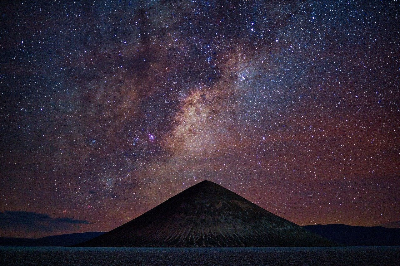
One unexpected highlight: the darkness. Far from any major city, the Beartooth area offers some of the darkest skies in the Lower 48. I lingered at a pullout until well after sunset, watching the Milky Way emerge in jaw-dropping detail. If you have a lightweight travel tripod, night sky photography here is phenomenal—and you’ll likely have the place completely to yourself after sunset.
Just remember that temperatures plummet after dark at these elevations. What felt pleasant at 60°F during the day can drop below freezing overnight, even in July. Pack accordingly if you’re planning any after-dark activities.
Why This Drive Changed How I Travel
I used to be the type who rushed from point A to point B, checking destinations off a list like items on a grocery run. The Beartooth Highway changed that. Somewhere between the third scenic overlook and the seventh switchback, I realized that the journey itself was the destination—that there’s profound value in slowing down and actually experiencing a place rather than just documenting it.
This drive isn’t about reaching Cooke City or entering Yellowstone. It’s about the transformation that happens between Red Lodge and the pass, about the way mountain light changes every five minutes, about the conversations with strangers at pullouts who are equally awestruck by the view. It’s about driving slowly enough to catch the scent of pine and damp earth, about stopping whenever you want because there’s nowhere else you need to be.
That’s the magic of the Beartooth Highway. It forces you to be present. You can’t phone it in—you’re too busy watching the road, too breathless from the elevation, too overwhelmed by the scenery to check your email or worry about tomorrow’s meetings. For a few precious hours, you’re just another human on a mountain road, sharing a moment of collective wonder with everyone else who made the drive.
Making It Your Own
Here’s the thing about the Beartooth Highway: my experience won’t be yours, and that’s exactly how it should be. You might encounter different weather, spot different wildlife, stop at different pullouts. You might tackle it in a sports car or a campervan, solo or with a carful of friends. You might rush through in three hours or linger for three days.
Whatever your approach, the Beartooth Highway will deliver. This road has been moving people for generations, and I’m willing to bet it’ll move you too. Just don’t make my mistake of thinking you can squeeze it into a quick drive-by—this is one of those places that demands you slow down and pay attention.
The mountains will be there whenever you finally make the drive. But trust me: once you experience that first view from the pass, once you feel the thin mountain air in your lungs and see endless peaks stretching to the horizon, you’ll understand why people return to this road again and again. Some journeys don’t need to be rushed—and the Beartooth Highway might just be the ultimate example.
Getting There and Planning Your Trip
The Beartooth Highway (U.S. Route 212) connects Red Lodge, Montana, to Cooke City, Montana, via Wyoming. Most travelers start in Red Lodge, which is accessible via Interstate 90 (approximately 1 hour from Billings, Montana). The nearest major airports are Billings Logan International Airport (BIL) or Bozeman Yellowstone International Airport (BZN).
Park entry fees apply if you continue into Yellowstone National Park via the Northeast Entrance. Consider purchasing the America the Beautiful Pass if you plan to visit multiple national parks within a year—it’ll pay for itself quickly.
For current road conditions, check the Montana Department of Transportation and National Park Service websites before departure. The road can close unexpectedly due to weather even during summer months, so flexibility in your travel plans is essential.
This drive has been on my bucket list for years, and it exceeded every expectation. The Beartooth Highway isn’t just America’s most beautiful roadway—it’s a reminder that sometimes the best journeys are the ones that take us to places we never knew we needed to go. Now that you know how to tackle it, there’s only one question left: when are you going to make the drive?
2 thoughts on “Driving the Beartooth Highway: The Ultimate Guide to America’s Most Beautiful Road Trip”